
Toronto’s new pedestrian wayfinding signage
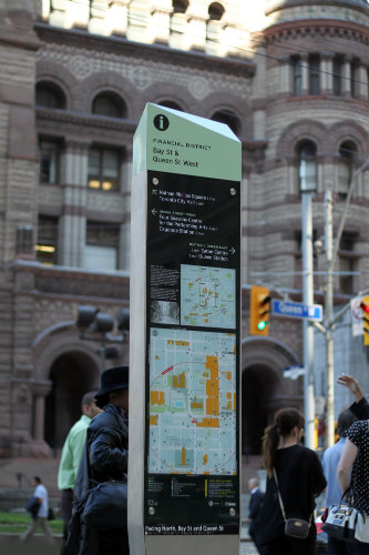
A prototype of Toronto’s new wayfinding signage, from www.toronto.ca.
Toronto is poised to make it a whole lot easier for pedestrians and cyclists to navigate the city’s downtown core. The city is piloting the Toronto 360 Wayfinding Strategy, which features maps, signs, and electronic components aimed at helping non-motorists get around town.
Be honest: Have you ever been wandering around on foot and pulled out a mobile app intended for car traffic? Sure, there might be a “walking” option on your app, but that’s not really what the app was designed for.
And, of course, your ability to use the app in the first place is contingent on:
- Cell reception, which can be difficult in downtown areas with lots of interference from skyscrapers.
- Cell battery. “Okay, I’ll just look at this map once and then navigate the next 72 blocks via memory since otherwise my phone will die…”
- Cell coverage. If you’re visiting from out of the country and your phone’s plan doesn’t cover wherever you are, you’re out of luck.
- Your data plan.
Did we mention that staring at your phone will trying to get around on foot is a great way to get run over? And let’s not even talk about trying to use your phone while riding a bike in traffic.
As dramatically as navigation apps have advanced over the past few years, they’re still not the be-all and end-all for pedestrians and cyclists. That’s where signage comes in. These aren’t the signs of the past that have a vaguely oriented arrow and a destination name with no indication of how far it is or how exactly you get there. Nor are they the slightly more advanced “you are here” maps that we’re used to seeing in malls.
Wayfinding signage like the program being piloted in Toronto is about as user-friendly as it gets. A similar program was implemented in the famously labyrinthine city of London in 2011, and it has doubtlessly saved a whole lot of would-be aimless wanderers.
Arguably the coolest component of the Toronto 360 Wayfinding Strategy are the info-pillar maps. These multi-sided signs feature detailed maps of pedestrian and cycling routes, but that’s just the beginning. Around the “you are here” designation, you’ll find a circle labeled with an estimated walking time, such as 10 minutes. If you walk at average speed, you should be able to reach anywhere within that circle in 10 minutes. That’s a whole lot more useful than the “one inch equals 0.1 miles” scale keys on most signs.
Many signs in the Toronto 360 Wayfinding Strategy will also include:
- Information about where exactly you are (not just a point on a map, but the actual intersection and neighborhood)
- Information about what direction you’re currently facing, which changes depending on which side of the map you’re looking at, to facilitate orientation
- Call-outs for landmarks or major streets with arrows pointing at the actual streets
The city intends to integrate electronic wayfinding apps into the Toronto 360 Wayfinding Strategy so those of us with sufficient cell coverage and battery life (and the smarts to actually look up from our phones when we’re crossing a street) can supplement the signage. However, the idea is that the signs themselves are sufficient to support navigation.
The pilot project “includes 25 signs and finger posts, 38 updated transit shelter maps and a dozen updated info-pillar maps,” according to CityNews. The city will collect information on the pilot in early 2016, perform an economic analysis, and then make recommendations for a citywide rollout.
Toronto is not only Canada’s largest city, but it’s the fourth largest city in North America. If smart, well-designed signage can help the city’s 2.8 million residents and innumerable tourists get around without needing a car, there are major implications for other cities looking to encourage greener transportation.